Industries
Purpose-built drone solutions for the autonomous location and air quality/site assessment of buried oil and gas infrastructure.
Industries We Serve
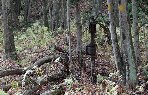
Buried and Undocumented Oil & Gas Infrastructure Mapping
Traditional ground-based locating of known and unknown wells and pipelines is a bottleneck for the energy sector. It is labor-intensive and costly, puts personnel at risk in remote or hazardous terrains, and better suited to coverage of small areas.
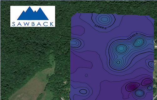
Sawback Technologies eliminates this bottleneck, using our drone agnostic sensor package that integrates advanced near-surface geophysical and gas (methane) spectrometers. Having multiple sensors deployed in the same drone flight empowers regulators, operators, and drone service providers to locate, map, and assess buried assets with sub-decimeter accuracy, over large and complex areas, cheaper and faster than conventional approaches.
The data from these sensors is then automatically processed on-edge, with probable locations of oil/gas wells identified and streamed in near real-time. Using this data, customers can reduce their liability from unknown oil/gas infrastructure, identify emissions and other pollution, and to support EPA Class VI permit applications, or remediation activities.
To date, our solution has collected data over tens of thousands of acres, ranging from Pennsylvania (USA) to British Columbia (Canada), with unknown wells identified, many of which leaking methane, with customers seeing a 60% reduction in the amount of scheduled effort and cost.
Our Technology Suite: Data Fusion for Deep Insights
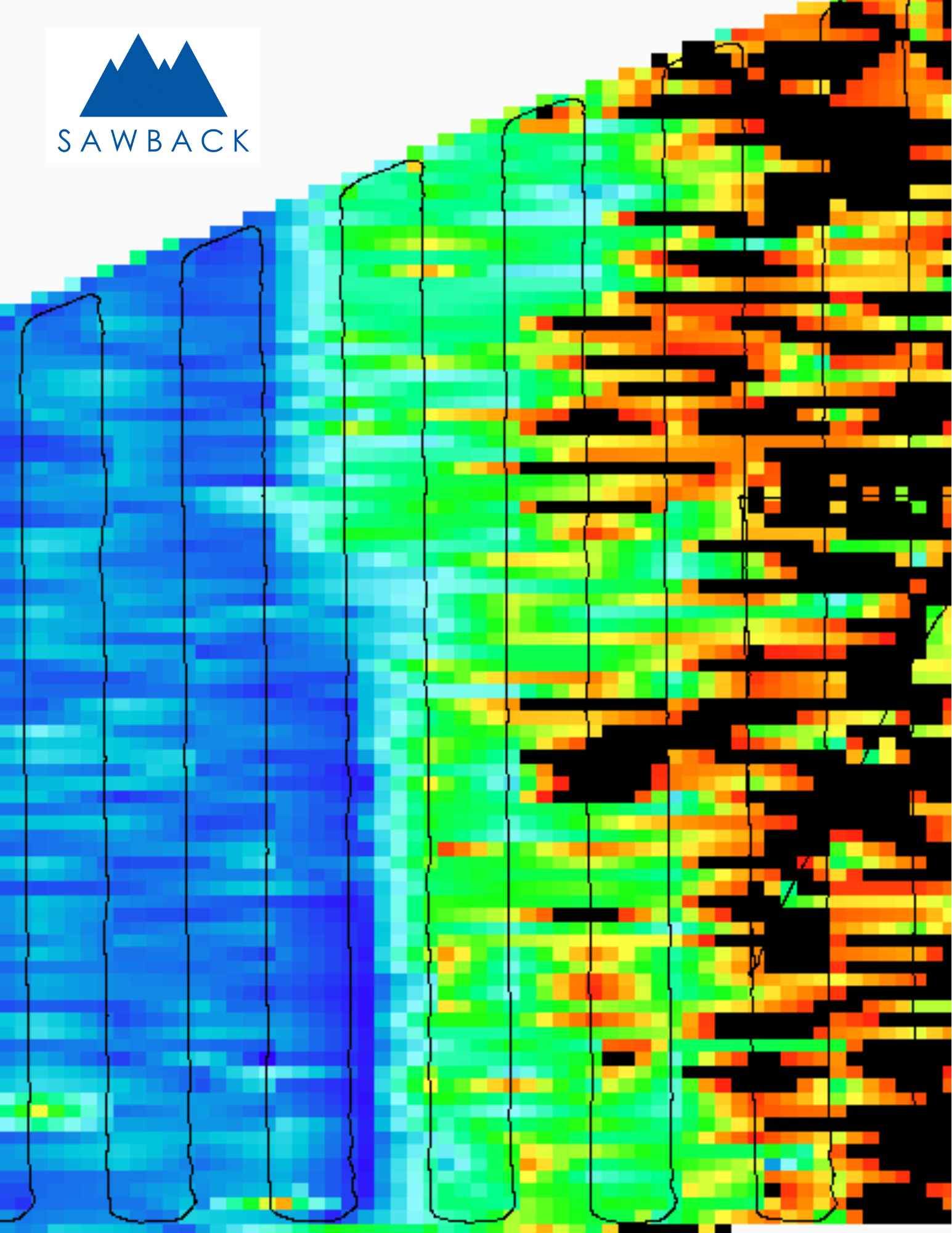
We don’t just fly sensors; we fuse data. Using the Sawback EdgeFuse™, we synchronize multiple sensor types to provide a comprehensive view of the subsurface.
1. Drone-Mounted Magnetometry
The Sawback EdgeFlux™ magnetometer is ideal for detecting metallic assets, including steel pipelines and well casings. Our high-sensitivity magnetometers identify magnetic anomalies to pinpoint exact coordinates of legacy infrastructure, either above, or below the ground.
2. Gas Spectrometers (methane)
For measurement of hydrocarbons, incl. natural gas, methane, as well as carbon dioxide, carbon monoxide, and nitrous oxide. Having the gas sensors deployed simultaneously with our EdgeFlux™ allows for efficient data fusion with magnetic data, allowing for rapid assessment if identified wells are emitting methane, without needing to dispatch, or perform another drone flight.
3. Automated Data Processing
All sensor data is processed through the EdgeFuse™, in near real-time, using our proprietary algorithms, transforming complex geophysical signals into visualizations by the drone operator and back-office engineers within minutes, not weeks.
Solving the Challenges of Legacy Oil and Gas Locations
Managing legacy infrastructure requires more than just a map. High quality aerial data, real-time data analysis and processing, and actionable visualizations help regulators and operators solve:
1) The “Lost” Asset Problem: Locating abandoned or undocumented wells and pipelines that appear on historical records, but have not been digitized to modern GIS standards.
2) Regulatory Compliance: Providing auditable documentation for liability and environmental purposes, when residential and commercial development occurs in legacy oil and gas locations.
3) Operational Safety: Removing field technicians from the hazards posed by steep and difficult terrain, environmentally sensitive areas, and dense vegetation.

Class VI Permit
EPA Class VI permit applications for carbon capture and storage projects require magnetometry surveys if the project area has legacy oil/gas wells. These wells are often located in areas that are inaccessible to helicopters, grown over with heavy vegetation, steep terrain, or waterbodies, making them expensive to find through traditional ground surveys.
Using drone-mounted EdgeFuse and magnetometer sensors can make this daunting task easier. Being able to cover large areas of land, and processing the data in-flight, makes this a more cost-effective, comprehensive, and safe, solution to find these lost wells.
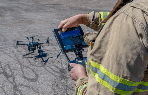
Drones
Drone operators spend too much time setting up sensors and processing data instead of flying.
Sawback Technologies simplifies this by enabling quick data and power connections for multiple sensors like magnetometers, ground-penetrating radar, and gas detectors. Its’ easy-to-use interface and weatherproof connectors ensure reliable data collection, reducing rework and maximizing flight time.
The Sawback Technologies EdgeFuse also processes and fuses data in-flight, providing near real-time insights. Once uploaded to the Sawback cloud-based software platform, automated reporting delivers results in popular formats, ready for use.
Want to streamline your workflow? Contact us to learn more!
Let’s connect
Their commitment to providing a better way of doing things is palpable in every aspect of their work. By seamlessly blending their diverse skillsets and extensive work experiences, Sawback Technologies has crafted a cutting-edge solution that addresses and diminishes the pain points inherent in the near-surface industry.
Sawback delivered on their promise to providing a faster way of finding abandoned wells, and making the data easy to use and read